SelectItemsByRegionBehavior Class
The Select by Region behavior settings.
Namespace: DevExpress.Xpf.Map
Assembly: DevExpress.Xpf.Map.v25.2.dll
NuGet Package: DevExpress.Wpf.Map
Declaration
Related API Members
The following members return SelectItemsByRegionBehavior objects:
Remarks
To implement custom allowed conditions for the Zoom to Region behavior, inherit this class and override the RegionBehaviorBase.Allowed property.
Example
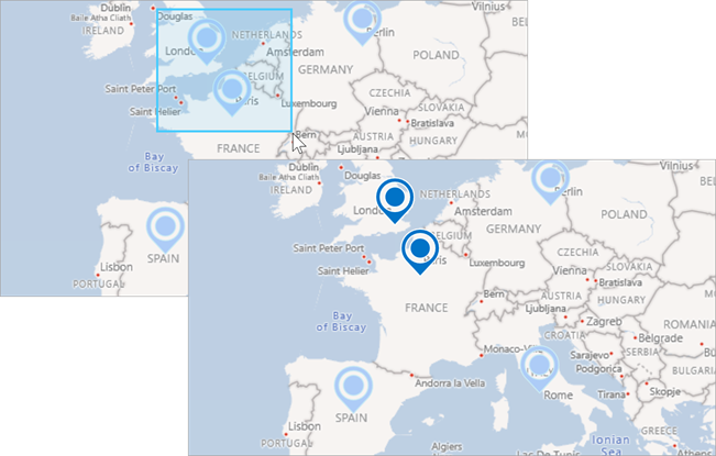
The following example shows how to add pushpins to a map and use Rectangular Selection to select multiple pushpins.

- A user should press the F3 key to enable/disable Rectangular Selection.
- A user should drag the mouse pointer while holding down the left mouse button and the Ctrl key to draw a selection rectangle.
<Window xmlns:dxm="http://schemas.devexpress.com/winfx/2008/xaml/map"
        x:Class="WpfMapSample.MainWindow"
        xmlns="http://schemas.microsoft.com/winfx/2006/xaml/presentation"
        xmlns:x="http://schemas.microsoft.com/winfx/2006/xaml"
        Title="MainWindow" Height="500" Width="800">
    <Grid>
        <dxm:MapControl x:Name="mapControl"
                        CenterPoint="45,18"
                        ZoomLevel="3"
                        SelectionMode="Multiple">

            <dxm:MapControl.SelectItemsByRegionBehavior>
                <dxm:SelectItemsByRegionBehavior Key="F3"
                                                 ModifierKeys="Ctrl"/>
            </dxm:MapControl.SelectItemsByRegionBehavior>

            <dxm:ImageLayer>
                <dxm:ImageLayer.DataProvider>
                    <dxm:BingMapDataProvider Kind="RoadLight"
                                             BingKey="Insert your BingMaps key."/>
                </dxm:ImageLayer.DataProvider>
            </dxm:ImageLayer>
            <dxm:VectorLayer x:Name="vectorLayer"
                             DataLoaded="OnVectorLayerDataLoaded">
                <dxm:VectorLayer.Data>
                    <dxm:ListSourceDataAdapter x:Name="listSourceDataAdapter"
                                               DataSource="{Binding}">
                        <dxm:ListSourceDataAdapter.Mappings>
                            <dxm:MapItemMappingInfo Latitude="Latitude"
                                                    Longitude="Longitude"/>
                        </dxm:ListSourceDataAdapter.Mappings>
                        <dxm:ListSourceDataAdapter.ItemSettings>
                            <dxm:MapPushpinSettings/>
                        </dxm:ListSourceDataAdapter.ItemSettings>
                    </dxm:ListSourceDataAdapter>
                </dxm:VectorLayer.Data>
            </dxm:VectorLayer>

            <dxm:MapControl.CoordinatesPanelOptions>
                <dxm:CoordinatesPanelOptions Visible="False"/>
            </dxm:MapControl.CoordinatesPanelOptions>
            <dxm:MapControl.ScalePanelOptions>
                <dxm:ScalePanelOptions Visible="False"/>
            </dxm:MapControl.ScalePanelOptions>
        </dxm:MapControl>
    </Grid>
</Window>
using DevExpress.Xpf.Map;
using System.Collections.ObjectModel;
using System.Windows;
namespace WpfMapSample {
    public partial class MainWindow : Window {
        ObservableCollection<GeoPoint> Data { get; set; }
        public MainWindow() {
            InitializeComponent();
            Data = new ObservableCollection<GeoPoint>();
            Data.Add(new GeoPoint(51.30, 0.07));
            Data.Add(new GeoPoint(52.31, 13.23));
            Data.Add(new GeoPoint(48.51, 2.21));
            Data.Add(new GeoPoint(41.54, 12.3));
            Data.Add(new GeoPoint(40.23, -3.43));
            this.DataContext = Data;
        }
        private void OnVectorLayerDataLoaded(object sender, DataLoadedEventArgs e) {
            mapControl.ZoomToFitLayerItems(new LayerBase[] { vectorLayer }, paddingFactor: 0.3);
        }
    }
}
Inheritance
Object
DispatcherObject
DependencyObject
Freezable
MapDependencyObject
RegionBehaviorBase
SelectItemsByRegionBehavior
See Also