Measurements Class
Contains API to manage rulers that help users measure distances and areas on a map.
Namespace: DevExpress.XtraMap
Assembly: DevExpress.XtraMap.v26.1.dll
Declaration
public class Measurements :
    IMapEditor,
    IRulerActionListener,
    IMapRulerStyleProvider,
    IMapStyleOwner,
IMapOverlayActionListenerRelated API Members
The following members return Measurements objects:
Remarks
The Measurements class allows you to manage distance and area rulers on a map.
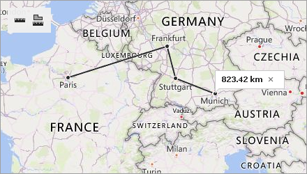
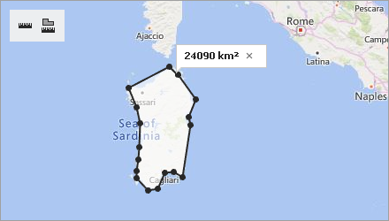
| Distance Ruler | Area Ruler |
|---|---|
 |
 |
Measurements Toolbar
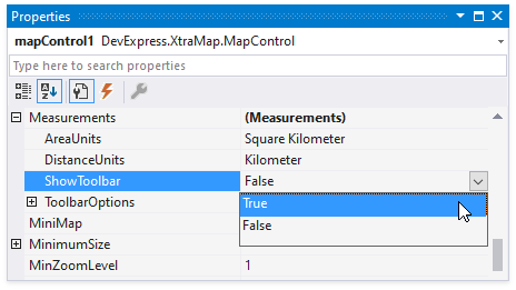
The Measurements toolbar contains buttons that allow users to add rulers to a map. To display this toolbar, set the ShowToolbar property to true in the Properties window at design time.
Use the code below to show the toolbar at runtime.
Toolbar buttons include:
Button | Name | Visibility |
|---|---|---|
| Add Distance Ruler | |
| Add Area Ruler |


Distance Ruler
The distance ruler calculates the distance between two or more points on a map. The total distance is shown in a map callout. Note that measurements ignore changes in elevation.
Click an intermediate point on the ruler to see the distance to this point.
To specify the measurement unit for the newly created distance ruler, set the DistanceUnits property to one of the following values:
To apply the distance unit to the ruler, specify the unit before you create the ruler. The following code creates a ruler that measures distance in miles:
mapControl1.Measurements.DistanceUnits = MeasureUnit.Mile;
MapRuler ruler= mapControl1.Measurements.CreateRuler(RulerType.Distance, new List<CoordPoint>() {
                                                                                  new GeoPoint(0, 0),
                                                                                  new GeoPoint(10, 0),
                                                                                  new GeoPoint(10, 10)});
Area Ruler
The area ruler calculates the area inside a polygon. The result is shown in a map callout.
To define the area measurement unit, set the AreaUnits property to one of the following values:
- Acre
- Hectare
- SquareCentimeter
- SquareFoot
- SquareInch
- SquareKilometer
- SquareMeter
- SquareMile
- SquareMillimeter
- SquareYard
To apply the area unit to the ruler, specify the unit before you create the ruler. The following code creates a ruler that measures the area in square miles:
mapControl1.Measurements.AreaUnits = AreaMeasurementUnit.SquareMile;
MapRuler ruler= mapControl1.Measurements.CreateRuler(RulerType.Area, new List<CoordPoint>() {
                                                                                  new GeoPoint(0, 0),
                                                                                  new GeoPoint(10, 0),
                                                                                  new GeoPoint(10, 10) });
Ruler Management
Create Rulers
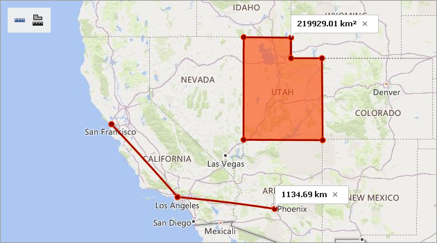
To create a ruler, a user can click the Add Distance Ruler or Add Area Ruler toolbar button, click the map to set ruler points, and then double-click the map to complete the ruler.
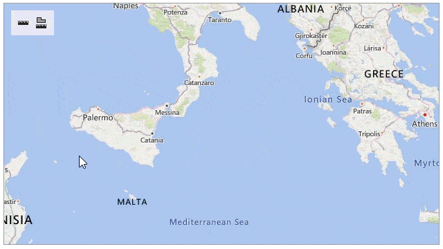
The following image shows how to create an area ruler:
You can also call the SetCreateMode(RulerType) method to activate the Measurements object’s Create mode. In this mode, users can click the map to create a ruler. They do not need to click toolbar buttons.
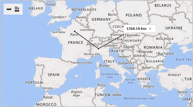
To create a ruler programmatically, call the CreateRuler(RulerType, IList<CoordPoint>) method. The following code creates a distance ruler:
MapRuler ruler = mapControl1.Measurements.CreateRuler(RulerType.Distance,
                                                        new List<CoordPoint>(){
                                                           new GeoPoint(48.864716, 2.349014),   // Paris
                                                           new GeoPoint(45.46427, 9.18951),     // Milan
                                                           new GeoPoint(48.20849, 16.37208) }); // Vienna
Configure Rulers
After a ruler is created, the Measurements object activates Edit mode. The SetEditMode() method also enables Edit mode.
The following actions are available in Edit mode:
Action | Description |
|---|---|
Add a ruler point. | Click the position on the ruler where you wish to add a point. |
Change the ruler polyline. | Click and drag the point to a new location. |
Delete a ruler point. | Double-click the ruler point. |
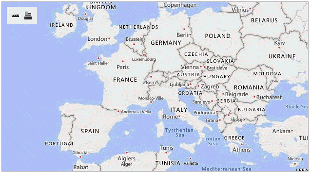
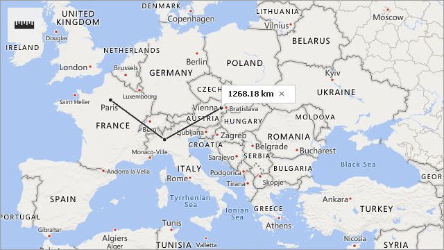
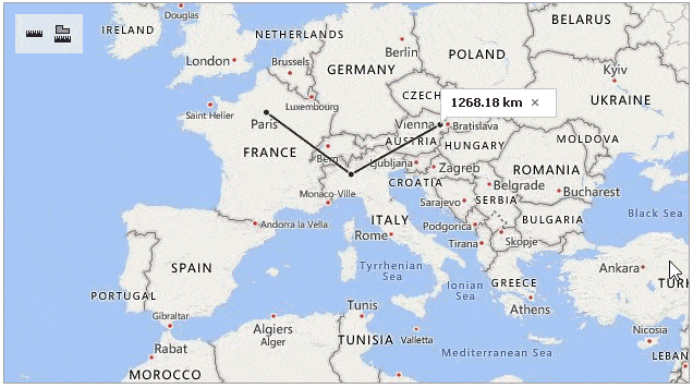
The image below shows how to change a distance ruler:
Use the following methods to configure a ruler programmatically:
Name | Description |
|---|---|
Adds a new point to the ruler. | |
Removes the point with the specified index. | |
Changes the coordinates of the point with the specified index. |
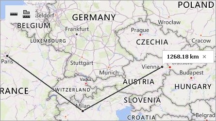
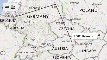
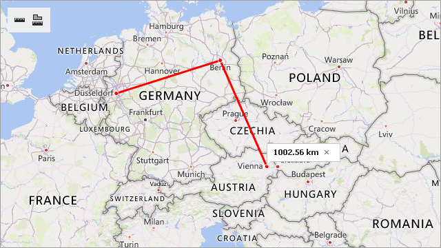
The example below creates a ruler to measure the distance between Paris, Milan and Vienna. After calculating this distance, the code updates the ruler as follows:
- a point is added at Berlin’s coordinates;
- the first point is moved from Paris to Dusseldorf;
- the point at Milan’s coordinates is removed from the ruler.
MapRuler ruler = mapControl1.Measurements.CreateRuler(RulerType.Distance,
                                                        new List<CoordPoint>() {
                                                            new GeoPoint(48.864716, 2.349014), // Paris
                                                            new GeoPoint(45.46427, 9.18951),   // Milan
                                                            new GeoPoint(48.20849, 16.37208)   // Vienna
                                                        });
//The code below updates the ruler.
mapControl1.Measurements.InsertPoint(ruler, new GeoPoint(52.520008, 13.404954), 2); // Berlin
mapControl1.Measurements.UpdatePoint(ruler, new GeoPoint(51.2217200, 6.7761600), 0); // Dusseldorf
mapControl1.Measurements.RemovePoint(ruler, 1); // Milan
| Before Update | After Update |
|---|---|
 |
 |
Remove Rulers
To remove a ruler, a user can click the cross button on the map callout that displays the ruler’s measurement value:
The RemoveRuler(MapRuler) method removes the ruler passed as a parameter.
To delete all rulers from the map, call the RemoveRulers() method.
Control Ruler Creation
You can handle the BeforeMeasurement and AfterMeasurement events to implement custom logic during ruler creation.
The example below cancels ruler creation if a ruler starts inside an ellipse. The MapControl.CalcHitInfo method returns information on the map elements located at the ruler’s first point. The e.StartPoint property returns this point.
private void Measurements_BeforeMeasurement(object sender, BeforeMeasurementEventArgs e) {
 MapHitInfo info = this.mapControl1.CalcHitInfo(e.StartPoint);
 if (info.InMapEllipse) {
     e.Cancel = true;
 }
}
The following example cancels area ruler creation. First, use the e.MapRuler property in the AfterMeasurement event handler to get the newly created ruler. To determine whether this ruler is an area ruler, use the MapRuler.RulerType property. If it is an area ruler, set the e.Cancel property to true to prevent the ruler from being displayed.
private void Measurements_AfterMeasurement(object sender, AfterMeasurementEventArgs e) {
  MapRuler ruler1 = e.MapRuler;
  if (ruler1.RulerType == RulerType.Area) {
      e.Cancel = true;
  }
}
Tip
You can also use the GeoUtils class to calculate geometric values on the map. This class contains cartography measurement API for maps with a geographic coordinate system.
Customize Ruler Appearance
Use the Style property to define the style for all rulers on the map.
mapControl1.Measurements.Style.Fill = Color.OrangeRed;
mapControl1.Measurements.Style.AreaTransparency = 100;
mapControl1.Measurements.Style.Stroke = Color.DarkRed;
mapControl1.Measurements.Style.StrokeWidth = 2;
The fill color is also used to draw the outline border of area rulers and distance ruler borders.
To change style settings for a newly created ruler, handle the BeforeMeasurement event. Use the e.Style property to define a new ruler style as follows:
private void Measurements_BeforeMeasurement(object sender, BeforeMeasurementEventArgs e) {
  e.Style.Stroke = Color.Gray;
  e.Style.StrokeWidth = 4;
}
You can also call the CreateRuler(RulerType, IList<CoordPoint>, MapRulerStyle) method and pass ruler style options as the style parameter.
The following example changes the ruler’s outline color and width:
MapRulerStyle style = new MapRulerStyle();
style.Stroke = Color.Red;
style.StrokeWidth = 3;
MapRuler ruler1 = mapControl1.Measurements.CreateRuler(RulerType.Distance,
                                                      new List<CoordPoint>() {
                                                          new GeoPoint(51.2217200, 6.7761600), // Dusseldorf
                                                          new GeoPoint(52.520008, 13.404954),  // Berlin
                                                          new GeoPoint(48.20849, 16.37208)   // Vienna
                                                      }, style);