MapRuler Class
Draws a ruler on the map.
Namespace: DevExpress.XtraMap
Assembly: DevExpress.XtraMap.v26.1.dll
Declaration
Related API Members
The following members return MapRuler objects:
Remarks
The Map Control uses rulers to measure distances and areas on a map. Two types of rulers are supported:
| Distance Ruler | Area Ruler |
|---|---|
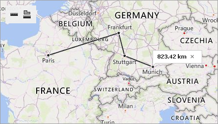 |
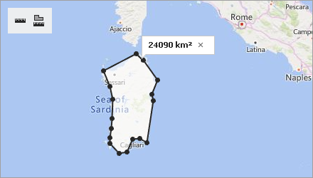 |
Create Ruler
Use the Measurements.CreateRuler method to add a ruler to the map. The following code displays a distance ruler on the map:
MapRuler ruler = mapControl1.Measurements.CreateRuler( RulerType.Distance,
                                                        new List<CoordPoint>(){
                                                           new GeoPoint(48.864716, 2.349014),   // Paris
                                                           new GeoPoint(45.46427, 9.18951),     // Milan
                                                           new GeoPoint(48.20849, 16.37208) }); // Vienna
Configure Ruler Points
To modify a ruler, configure ruler points. You can use the following methods:
Name | Description |
|---|---|
Adds a new point to the ruler passed as a parameter. | |
Removes the point with the specified index. | |
Changes coordinates of the point with the specified index. |
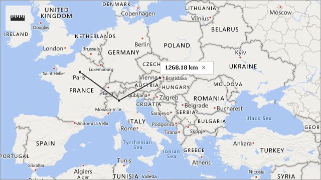
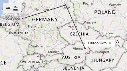
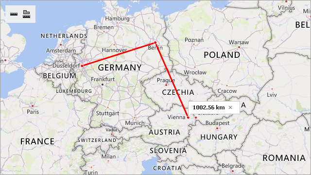
The example below creates a ruler to measure the distance between Paris, Milan and Vienna. After calculating this distance, the code updates the ruler as follows:
- a point is added at Berlin’s coordinates;
- the first point is moved from Paris to Dusseldorf;
- the point at Milan’s coordinates is removed from the ruler.
MapRuler ruler = mapControl1.Measurements.CreateRuler(RulerType.Distance,
                                                        new List<CoordPoint>() {
                                                            new GeoPoint(48.864716, 2.349014), // Paris
                                                            new GeoPoint(45.46427, 9.18951),   // Milan
                                                            new GeoPoint(48.20849, 16.37208)   // Vienna
                                                        });
//The code below updates the ruler.
mapControl1.Measurements.InsertPoint(ruler, new GeoPoint(52.520008, 13.404954), 2); // Berlin
mapControl1.Measurements.UpdatePoint(ruler, new GeoPoint(51.2217200, 6.7761600), 0); // Dusseldorf
mapControl1.Measurements.RemovePoint(ruler, 1); // Milan
| Before Update | After Update |
|---|---|
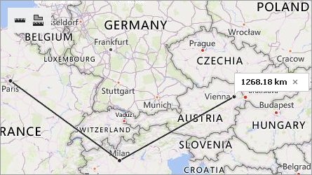 |
 |
Remove Ruler
The RemoveRuler(MapRuler) method removes the ruler passed as a parameter:
If you need to delete all rulers from the map, call the RemoveRulers() method:
Customize Ruler Appearance
Use the CreateRuler(RulerType, IList<CoordPoint>, MapRulerStyle) method to define the ruler’s appearance. The MapRulerStyle class contains ruler style options.
MapRulerStyle style = new MapRulerStyle();
style.Stroke = Color.Red;
style.StrokeWidth = 3;
MapRuler ruler1 = mapControl1.Measurements.CreateRuler(RulerType.Distance,
                                                      new List<CoordPoint>() {
                                                          new GeoPoint(51.2217200, 6.7761600), // Dusseldorf
                                                          new GeoPoint(52.520008, 13.404954),  // Berlin
                                                          new GeoPoint(48.20849, 16.37208)   // Vienna
                                                      }, style);
Related API members:
Name | Description |
|---|---|
Creates a ruler with the specified style. | |
Contains ruler style options. | |
Gets or sets the ruler’s outline color. | |
Gets or sets the ruler’s outline width. |