GeoUtils Class
Namespace: DevExpress.XtraMap
Assembly:
DevExpress.XtraMap.v26.1.dll
NuGet Package:
DevExpress.Win.Map
Declaration
public static class GeoUtils
The GeoUtils class provides methods that allow you to calculate geometric values (for example, a shape perimeter or area) based on geographical coordinates.
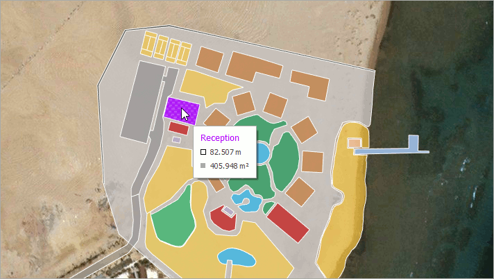
The following list contains the main GeoUtils methods:
CalculateArea(MapShape shape) computes a map shape’s total area, in square meters.
private void mapControl_SelectionChanged(object sender, MapSelectionChangedEventArgs e) {
    MapShape mapShape = vectorItemsLayer.SelectedItem as MapShape;
    double areaByShape = GeoUtils.CalculateArea(mapShape)/1000000;
    label.Text = $"Shape Area: {areaByShape:F2} km²";
}
Private Sub mapControl_SelectionChanged(ByVal sender As Object, ByVal e As MapSelectionChangedEventArgs)
    Dim mapShape As MapShape = CType(vectorItemsLayer.SelectedItem,MapShape)
    Dim areaByShape As Double = (GeoUtils.CalculateArea(mapShape) / 1000000)
    label.Text = "Area: {areaByShape:F2} km²"
End Sub
CalculateArea(IList<GeoPoint> points) calculates an area of the region given by geographical points, in square meters.
double areaByPoints = GeoUtils.CalculateArea(new List<GeoPoint> {
    new GeoPoint(41, -109),
    new GeoPoint(41, -102),
    new GeoPoint(37, -102),
    new GeoPoint(37, -109)
});
Dim areaByPoints As Double = GeoUtils.CalculateArea(New List(Of GeoPoint) From {
    New GeoPoint(41, -109),
    New GeoPoint(41, -102),
    New GeoPoint(37, -102),
    New GeoPoint(37, -109)
})
CalculateBearing(GeoPoint p1, GeoPoint p2) computes an angle between the Geodetic North direction and a line given by two points, clockwise in degrees.
double bearing = GeoUtils.CalculateBearing(new GeoPoint(36.1, -115.1), new GeoPoint(35.9, -115.9));
Dim bearing As Double = GeoUtils.CalculateBearing(New GeoPoint(36.1, -115.1), New GeoPoint(35.9, -115.9))
CalculateCenter(GeoPoint p1, GeoPoint p2) finds a center point between two geographical points.
GeoPoint centerPoint = GeoUtils.CalculateCenter(
    new GeoPoint(35.286, -111.1724),
    new GeoPoint(38.3802, -110.9307));
Dim centerPoint As GeoPoint = GeoUtils.CalculateCenter(New GeoPoint(35.286, -111.1724), New GeoPoint(38.3802, -110.9307))
CalculateDistance(GeoPoint p1, GeoPoint p2) determines the distance between two geographical points, in meters.
double distance = GeoUtils.CalculateDistance(new GeoPoint(36.1, -115.1), new GeoPoint(34, -118.2));
Dim distance As Double = GeoUtils.CalculateDistance(New GeoPoint(36.1, -115.1), New GeoPoint(34, -118.2))
CalculateDistance(GeoPoint p1, GeoPoint p2, Boolean ignoreEllipsoidalEffects) determines the distance between two geographical points in meters. This CalculateDistance method overload allows you to specify whether to use the ellipsoidal-surface formula or spherical-surface formula to calculate the distance.
using DevExpress.XtraMap;
//...
    private void simpleButton1_Click(object sender, EventArgs e) {
        double distance = GeoUtils.CalculateDistance(new GeoPoint(-5.93107, -35.112723), new GeoPoint(4.253438, 5.47072), true);
    }
Imports DevExpress.XtraMap
'...
    Private Sub simpleButton1_Click(ByVal sender As Object, ByVal e As EventArgs)
        Dim distance As Double = GeoUtils.CalculateDistance(New GeoPoint(-5.93107, -35.112723), New GeoPoint(4.253438, 5.47072), True)
    End Sub
CalculateDestinationPoint(GeoPoint startPoint, Double distance, Double bearing) calculates a geographical point based on the specified start point, distance, and bearing. The distance is measured along a geodesic line.
GeoPoint startPoint = new GeoPoint(53.1914, 001.4347);
GeoPoint destinationPoint = GeoUtils.CalculateDestinationPoint(startPoint, 17910000, 276.0117);
Dim startPoint As GeoPoint = New GeoPoint(53.1914, 001.4347)
Dim destinationPoint As GeoPoint = GeoUtils.CalculateDestinationPoint(startPoint, 17910000, 276.0117)
CalculateLength(IList<GeoPoint> points) calculates the polyline length, in meters.
double lineLength = GeoUtils.CalculateLength(new List<GeoPoint> {
    new GeoPoint(35.286, -111.1724),
    new GeoPoint(38.3802, -110.9307),
    new GeoPoint(36.9365, -102.493)
});
Dim lineLength As Double = GeoUtils.CalculateLength(New List(Of GeoPoint) From {
    New GeoPoint(35.286, -111.1724),
    New GeoPoint(38.3802, -110.9307),
    New GeoPoint(36.9365, -102.493)
})
CalculateStrokeLength(MapShape shape) returns the map shape’s stroke length, in meters.
private void mapControl_SelectionChanged(object sender, MapSelectionChangedEventArgs e) {
    MapShape mapShape = vectorItemsLayer.SelectedItem as MapShape;
    double strokeLength = GeoUtils.CalculateStrokeLength(mapShape);
    label.Text = $"StokeLength: {strokeLength / 1000:F2} km";
}
Private Sub mapControl_SelectionChanged(ByVal sender As Object, ByVal e As MapSelectionChangedEventArgs)
    Dim mapShape As MapShape = TryCast(vectorItemsLayer.SelectedItem, MapShape)
    Dim strokeLength As Double = GeoUtils.CalculateStrokeLength(mapShape)
    label.Text = $"StokeLength: {strokeLength / 1000} km"
End Sub
See Also