GeoPoint Class
A geographical point on the map.
Namespace: DevExpress.XtraMap
Assembly: DevExpress.XtraMap.v25.2.dll
NuGet Package: DevExpress.Win.Map
Declaration
Related API Members
The following members return GeoPoint objects:
Remarks
The GeoPoint structure introduces the GeoPoint.Latitude and GeoPoint.Longitude properties that defines a geographical point on the map.
Example
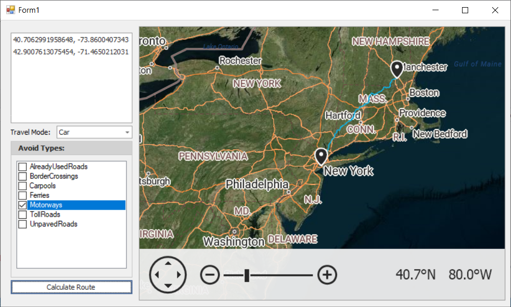
The following example calculates a route based on two or more RouteWaypoint objects.

Right-click on a map surface to specify waypoints: origin, destination, and points between. ListBox entries display geographical points (GeoPoint.Longitude and GeoPoint.Latitude). The “Calculate Route” button initiates the routing request by obtaining the waypoint information and passing it to the CalculateRoute method. The ComboBoxEdit and CheckedListBox editors specify route options (AzureRouteOptions.AvoidTypes and AzureRouteOptions.TravelMode properties).
using System.Collections.Generic;
using System.Collections.ObjectModel;
using System.Drawing;
using System.Linq;
using System.Windows.Forms;
using DevExpress.XtraMap;

namespace AzureRouting {
    public partial class Form1 : Form {
        const string azureKey = "your key";
        ObservableCollection<GeoPoint> geoPoints = new ObservableCollection<GeoPoint>();
        MapItemStorage itemData;
        InformationLayer routeInfoLayer;
        AzureRouteDataProvider azureRoute;
        public Form1() {
            InitializeComponent();
            mapControl.Layers.AddRange(
                new LayerBase[] {
                    new ImageLayer() {
                        DataProvider = new AzureMapDataProvider() {
                            AzureKey = azureKey,
                            Tileset = AzureTileset.Imagery,
                        },
                    },
                    new ImageLayer() {
                        DataProvider = new AzureMapDataProvider() {
                            AzureKey = azureKey,
                            Tileset = AzureTileset.BaseHybridRoad,
                        },
                    },
                    routeInfoLayer = new InformationLayer() {
                        DataProvider = azureRoute = new AzureRouteDataProvider() {
                            AzureKey = azureKey,
                        },
                    },
                    new VectorItemsLayer() {
                        Data = itemData = new MapItemStorage(),
                    }
                }
            );
            routeInfoLayer.ItemStyle.StrokeWidth = 2;
            routeInfoLayer.ItemStyle.Stroke = Color.DeepSkyBlue;
            routeInfoLayer.Error += RouteInfoLayer_Error;
            waypointsListBoxControl.DataSource = geoPoints;
            mapControl.Zoom(6);
            mapControl.SetCenterPoint(new GeoPoint(40.714627, -74.002863), false);
            mapControl.EnableRotation = false;
        }
        private void RouteInfoLayer_Error(object sender, MapErrorEventArgs e) {
            throw new System.NotImplementedException();
        }
        private void mapControl_Click(object sender, System.EventArgs e) {
            MouseEventArgs mouseEventArgs = (MouseEventArgs)e;
            if(mouseEventArgs.Button == MouseButtons.Right) {
                GeoPoint mousePoint = mapControl.ScreenPointToCoordPoint(mouseEventArgs.Location) as GeoPoint;
                geoPoints.Add(mousePoint);
                itemData.Items.Add(new MapPushpin() {
                    Location = mousePoint,
                });
            }
        }
        private void calculateRouteButton_Click(object sender, System.EventArgs e) {
            if (geoPoints.Count <= 1) {
                MessageBox.Show("Specify at least two Waypoints to calculate a route.");
                return;
            }
            azureRoute.CalculateRoute(geoPoints.Select(point => new RouteWaypoint("", point)).ToList(), new AzureRouteOptions() {
                TravelMode = GetTravelMode(),
                AvoidTypes = GetAvoidTypes()
            });
            geoPoints.Clear();
            itemData.Items.Clear();
        }
        AzureTravelMode GetTravelMode() {
            return (AzureTravelMode)Enum.Parse(typeof(AzureTravelMode), (string)travelModeComboBox.SelectedItem);
        }
        AzureRouteAvoidType GetAvoidTypes() {
            var avoidTypes = AzureRouteAvoidType.None;
            foreach (string item in avoidTypesCheckedListBox.CheckedItems) {
                var avoidType = (AzureRouteAvoidType)Enum.Parse(typeof(AzureRouteAvoidType), item);
                avoidTypes |= avoidType;
            }
            return avoidTypes;
        }
    }
}