How to: Calculate a Route between Waypoints Using the Bing Route Service
- 3 minutes to read
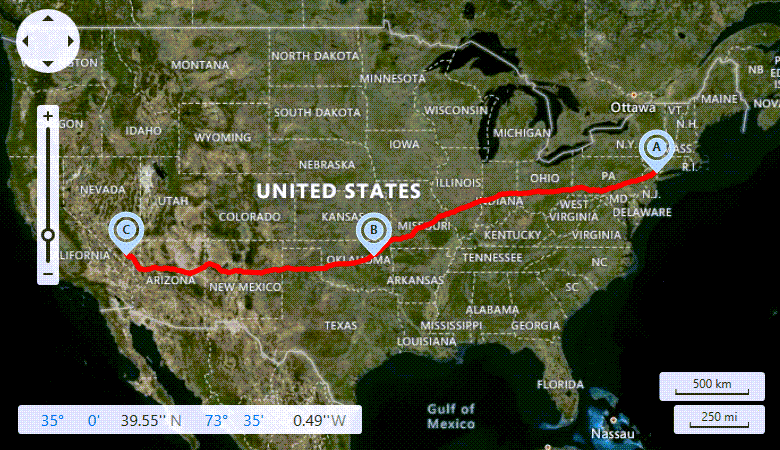
This example demonstrates how to use the Microsoft Bing Route web service to calculate a route between multiple waypoints and how to customize the appearance of the resulting route path.
Important
On May 21, 2024, Microsoft announced that Bing Maps for Enterprise and its API will be discontinued. Azure Maps will be a single unified enterprise mapping platform available from Microsoft.
To obtain and display map data from Azure Maps, we implemented the following providers:
- AzureMapDataProvider
- AzureSearchDataProvider
- AzureRouteDataProvider
- AzureGeocodeDataProvider
- AzureTrafficIncidentDataProvider
- AzureRouteIsochroneDataProvider
For information on how to migrate your app from Bing Maps to Azure Maps, see the following help topic: DevExpress Map Control for WPF: Migrate from Bing Maps to Azure Maps.
If you already have a Bing Maps for Enterprise license, you can keep using the current API. You must transition to the new API by June 30, 2025 (for free/basic licenses) or June 30, 2028 (for enterprise licenses). New licenses will no longer be available after June 30, 2025. Bing Maps will not work with our map controls without a license after that date.
To accomplish this, do the following:
- Create an InformationLayer object and add it to the MapControl.Layers collection.
Create a
BingRouteDataProviderobject and assign it to the InformationLayer.DataProvider property. Specify the provider’s key.To calculate a route, call the BingRouteDataProvider.CalculateRoute method and pass a list of waypoints as its argument.
Note
The BingRouteDataProvider.CalculateRoute method calculates the route based on less than 265 RouteWaypoint objects.
To customize the resulting route path’s appearance, handle the InformationDataProviderBase.LayerItemsGenerating event and configure appearance of the items contained in the event arguments (the
Itemsproperty). This example shows how to specify text displayed in generated pushpins and define colors used to draw the path between pushpins.The Map Control generates map pushpins for waypoints and raises the
LayerItemsGeneratingevent only when the InformationDataProviderBase.GenerateLayerItems property value is true. If the GenerateLayerItems property value is false, you can create pushpins or other map vector items based on your waypoints in the BingRouteDataProvider.RouteCalculated event handler.
<dxm:InformationLayer EnableHighlighting="False">
    <dxm:InformationLayer.DataProvider>
        <dxm:BingRouteDataProvider x:Name="routeProvider"
                                   BingKey="{Binding Source={StaticResource YourBingKey}}"
                                   LayerItemsGenerating="routeProvider_LayerItemsGenerating"/>
    </dxm:InformationLayer.DataProvider>
</dxm:InformationLayer>
public partial class MainWindow : Window {

    public MainWindow() {
        InitializeComponent();

        // Create three waypoints and add them to a route waypoints list.
        List<RouteWaypoint> waypoints = new List<RouteWaypoint>();
        waypoints.Add(new RouteWaypoint("New York", new GeoPoint(41.145556, -73.995)));
        waypoints.Add(new RouteWaypoint("Oklahoma", new GeoPoint(36.131389, -95.937222)));
        waypoints.Add(new RouteWaypoint("Las Vegas", new GeoPoint(36.175, -115.136389)));

        routeProvider.CalculateRoute(waypoints);
    }

    private void routeProvider_LayerItemsGenerating(object sender, LayerItemsGeneratingEventArgs args) {
        char letter = 'A';
        foreach (MapItem item in args.Items) {
            MapPushpin pushpin = item as MapPushpin;
            if (pushpin != null)
                pushpin.Text = letter++.ToString();
            MapPolyline line = item as MapPolyline;
            if (line != null) {
                line.Fill = Brushes.Red;
                line.Stroke = Brushes.Red;
            }
        }

        map.ZoomToFit(args.Items);
    }
}