Interactivity for the Geo Point Maps in the WinForms
This document describes the capabilities that enable interaction between Geo Point maps and other dashboard items. These capabilities include Master Filtering.
Master Filtering
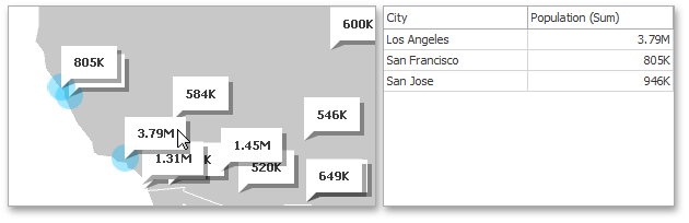
The BI Dashboard allows you to use Geo Point Maps as a filter for other dashboard items (Master Filter). To learn more, see the Master Filtering topic, which describes filtering concepts common to all dashboard items.
When Master Filtering is enabled, an end-user can click a callout/bubble/pie (or multiple callouts/bubbles/pies by holding down the CTRL key) to make other dashboard items only display data related to the selected callout(s)/bubble(s)/pie(s).
Note
When you select a clustered bubble or pie, master filtering is applied by all points that are clustered into this bubble/pie.
To learn how to enable Master Filtering in the Designer, see the Master Filtering topic.
To reset filtering, use the Clear Master Filter button ( ) in the Map’s caption area, or the Clear Master Filter command in the context menu.
Member Table
- DashboardItemInteractivityOptions.MasterFilterMode
- Gets or sets the selection mode of the master filter item.
- MapDashboardItem.InteractivityOptions
- Provides access to interactivity options, such as Master Filtering.