How to: Draw Lines on a Map using Google Maps API
- 3 minutes to read
This example demonstrates how to draw lines that connect the map markers using the Google Maps API in an ASP.NET Web Forms application created according to the Use Raster Maps tutorial.
- Add the WebPolylineController View Controller to the ASP.NET Web Forms module project.
- In the constructor, set the ViewController.TargetObjectType property to IMapsMarker and the ViewController.TargetViewType to ViewType.ListView.
- Override the OnViewControlsCreated method and access the WebMapsListEditor List Editor and its MapViewer control. This control exposes the MapViewer.ClientSideEvents property, which allows you to assign JavaScript handlers to the client-side events.
- Handle the MapViewerClientSideEvents.Customize client-side event and draw a polygon line that connects the displayed markers.
To access the markers list, use the CollectionSourceBase.List property of the ListView.CollectionSource.
using DevExpress.Persistent.Base;
using DevExpress.ExpressApp.Maps.Web;
using System.Web.Script.Serialization;
using DevExpress.ExpressApp.Maps.Web.Helpers;
// ...
public class WebPolylineController : ViewController<ListView> {
    public WebPolylineController() {
        TargetObjectType = typeof(IMapsMarker);
    }
    protected override void OnViewControlsCreated() {
        base.OnViewControlsCreated();

        WebMapsListEditor webMapsListEditor = ((ListView)View).Editor as WebMapsListEditor;
        if (webMapsListEditor != null)
            webMapsListEditor.MapViewer.ClientSideEvents.Customize = GetCustomizeScript();
    }
    private IEnumerable<MapPoint> GetPolylinePoints() {
        List<MapPoint> polylinePoints = new List<MapPoint>();
        foreach (IMapsMarker marker in View.CollectionSource.List) {
            polylinePoints.Add(new MapPoint(marker.Latitude, marker.Longitude));
        }
        return polylinePoints;
    }
    private string GetCustomizeScript() {
        var jsSerializer = new JavaScriptSerializer();
        string polylines = jsSerializer.Serialize(GetPolylinePoints());
        return string.Format(
@"function(sender, map) {{
    map.on('ready', function(e) {{
        var googleMap = e.originalMap;
        var flightPlanCoordinates = {0};
        var flightPath = new google.maps.Polyline({{
        path: flightPlanCoordinates,
        strokeColor: '#FF0000',
        strokeOpacity: 1.0,
        strokeWeight: 2
        }});

        flightPath.setMap(googleMap);
    }});
}}", polylines);
    }
}
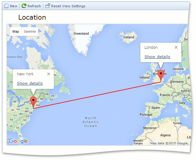
Run the application and create several markers. The result is demonstrated in the image below.
See Also