GpxFileDataAdapter Class
Namespace: DevExpress.XtraMap
Assembly: DevExpress.XtraMap.v25.1.dll
NuGet Package: DevExpress.Win.Map
Declaration
Remarks
Tip
To try out the GpxFileDataAdapter, see the GPX Data Adapter demo.
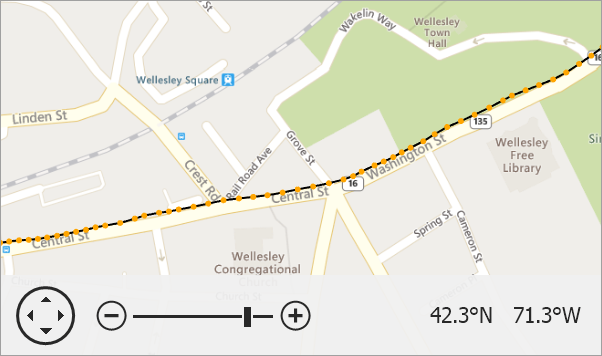
GPX files store coordinate-based data such as waypoints, routes, and tracks in an XML-like format.
The Map Control converts GPX file elements as follows:
<wpt>(waypoint) is displayed as MapDot.<rte>(route) is converted to a MapPolyline.<trk>(track) is represented by a MapPath.
Routes and tracks are built based on trkpt coordinates nested inside <rte> or <trk> elements. If you enable the CreateRoutePoints property, map dots are generated for each trkpt element.
Follow the steps below to load data from a .GPX file:
- Add a VectorItemsLayer object to the MapControl.Layers collection.
- Create a GpxFileDataAdapter object.
- Specify the path to a GPX file via the FileDataAdapterBase.FileUri property.
- Assign the GpxFileDataAdapter to the VectorItemsLayer.Data property.
private void Form1_Load(object sender, EventArgs e) {

    ImageLayer imageLayer = new ImageLayer() {
        DataProvider = new BingMapDataProvider {
            BingKey = "Insert_your_BingKey_here",
            Kind = BingMapKind.Road
        }
    };
    mapControl1.Layers.Add(imageLayer);

    VectorItemsLayer vectorLayer = new VectorItemsLayer();
    mapControl1.Layers.Add(vectorLayer);

    GpxFileDataAdapter dataAdapter = new GpxFileDataAdapter();
    dataAdapter.FileUri = new Uri(GetRelativePath("boston-marathon-course.gpx"));
    vectorLayer.Data = dataAdapter;

    dataAdapter.CreateRoutePoints = true;

    // Use the ItemsLoaded event to customize items the adapter generates.
    dataAdapter.ItemsLoaded += OnDataAdapterItemsLoaded;

    // You can call the MapControl.ZoomToFitLayerItems method in the DataLoaded event handler
    // to zoom the map so that it displays all vector items.
    vectorLayer.DataLoaded += OnVectorLayerDataLoaded;
}

private void OnDataAdapterItemsLoaded(object sender, ItemsLoadedEventArgs e) {
    foreach (MapItem item in e.Items) {
        if (item is MapPath) {
            item.Stroke = Color.Black;
            item.StrokeWidth = 2;
        }
        if (item is MapDot) {
            item.Fill = Color.Orange;
            item.Stroke = Color.Orange;
        }
    }
}

private void OnVectorLayerDataLoaded(object sender, DataLoadedEventArgs e) {
    mapControl1.ZoomToFitLayerItems(new LayerBase[] { mapControl1.Layers[1] });
}

public static string GetRelativePath(string name) {
    DirectoryInfo dir = new DirectoryInfo(Application.StartupPath);
    while (dir != null) {
        string filePath = Path.Combine(dir.FullName, name);
        if (File.Exists(filePath))
            return filePath;
        dir = Directory.GetParent(dir.FullName);
    }
    return string.Empty;
}
Implements
Inheritance
Object
MapDisposableObject
MapDataAdapterBase
CoordinateSystemDataAdapterBase
DevExpress.XtraMap.OuterDataAdapterBase
FileDataAdapterBase
GpxFileDataAdapter
See Also