How to: Automatically Generate Vector Items from a Datasource
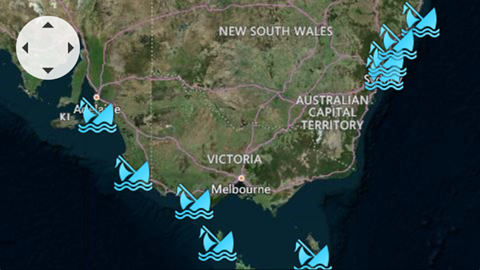
This example shows how to use the ListSourceDataAdapter to load shipwreck information from an XML file and display wrecked ship images on a map.

- Create a ListSourceDataAdapter object and assign it to the VectorLayer.Data property.
- Specify the DataSourceAdapterBase.DataSource property.
- Configure the ListSourceDataAdapter.Mappings property to assign data source field values to map items.
- Use the ListSourceDataAdapter.ItemSettings property to specify map item settings.
<dxm:VectorLayer.Data>
    <dxm:ListSourceDataAdapter DataSource="{Binding Source={StaticResource data}, XPath=Ship}">
        <dxm:ListSourceDataAdapter.AttributeMappings>
            <dxm:MapItemAttributeMapping Name="Name" Member="Name"/>
            <dxm:MapItemAttributeMapping Name="Year" Member="Year"/>
            <dxm:MapItemAttributeMapping Name="Description" Member="Description"/>
        </dxm:ListSourceDataAdapter.AttributeMappings>
        <dxm:ListSourceDataAdapter.Mappings>
            <dxm:MapItemMappingInfo Latitude="Latitude" Longitude="Longitude"/>
        </dxm:ListSourceDataAdapter.Mappings>
        <dxm:ListSourceDataAdapter.ItemSettings>
            <dxm:MapCustomElementSettings ContentTemplate="{Binding Source={StaticResource itemTemplate}}"/>
        </dxm:ListSourceDataAdapter.ItemSettings>
    </dxm:ListSourceDataAdapter>
</dxm:VectorLayer.Data>
The structure of the XML file used in the example looks as follows:
Show XML
<?xml version="1.0" standalone="yes"?>
<Ships>
  <Ship>
    <Year>1898</Year>
    <Name>Koonya</Name>
    <Description>A steamboat that ran aground off Cronulla Beach.</Description>
    <Latitude>-34.042876</Latitude>
    <Longitude>151.206777</Longitude>
  </Ship>
  <Ship>
    <Year>1809</Year>
    <Name>Hazard</Name>
    <Description>A sloop that ran aground on Box Head.</Description>
    <Latitude>-33.54227</Latitude>
    <Longitude>151.3485</Longitude>
  </Ship>
  <!--...-->
</Ships>
See Also