How to: Draw Lines on a Map using Google Maps API
- 5 minutes to read
This example demonstrates how to draw lines that connect the map markers using the Google Maps API in a Mobile or an ASP.NET application created according to the Use Raster Maps tutorial.
ASP.NET-Oriented Controller
- Add the WebPolylineController View Controller to the ASP.NET module project.
- In the constructor, set the ViewController.TargetObjectType property to IMapsMarker and the ViewController.TargetViewType to ViewType.ListView.
- Override the OnViewControlsCreated method and access the WebMapsListEditor List Editor and its MapViewer control. This control exposes the MapViewer.ClientSideEvents property, which allows you to assign JavaScript handlers to the client-side events.
- Handle the MapViewerClientSideEvents.Customize client-side event and draw a polygon line that connects the displayed markers.
- To access the markers list, use the CollectionSourceBase.List property of the ListView.CollectionSource.
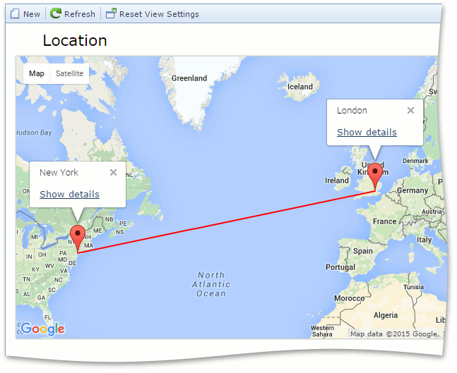
using DevExpress.Persistent.Base; using DevExpress.ExpressApp.Maps.Web; using System.Web.Script.Serialization; using DevExpress.ExpressApp.Maps.Web.Helpers; // ... public class WebPolylineController : ViewController<ListView> { public WebPolylineController() { TargetObjectType = typeof(IMapsMarker); } protected override void OnViewControlsCreated() { base.OnViewControlsCreated(); WebMapsListEditor webMapsListEditor = ((ListView)View).Editor as WebMapsListEditor; if (webMapsListEditor != null) webMapsListEditor.MapViewer.ClientSideEvents.Customize = GetCustomizeScript(); } private IEnumerable<MapPoint> GetPolylinePoints() { List<MapPoint> polylinePoints = new List<MapPoint>(); foreach (IMapsMarker marker in View.CollectionSource.List) { polylinePoints.Add(new MapPoint(marker.Latitude, marker.Longitude)); } return polylinePoints; } private string GetCustomizeScript() { var jsSerializer = new JavaScriptSerializer(); string polylines = jsSerializer.Serialize(GetPolylinePoints()); return string.Format( @"function(sender, map) {{ map.on('ready', function(e) {{ var googleMap = e.originalMap; var flightPlanCoordinates = {0}; var flightPath = new google.maps.Polyline({{ path: flightPlanCoordinates, strokeColor: '#FF0000', strokeOpacity: 1.0, strokeWeight: 2 }}); flightPath.setMap(googleMap); }}); }}", polylines); } }Run the application and create several markers. The result is demonstrated in the image below.
Mobile-Oriented Controller
- Add the MobilePolylineController View Controller to the Mobile module project.
- In the constructor, set the ViewController.TargetViewId property to MapsMarker_ListView.
- Override the OnViewControlsCreated method and access the MobileMapsListEditor List Editor and its Map control. This control exposes the Map.OnCustomize property, which allows you to assign JavaScript code to draw a polygon line that connects the specified map points. Note that JavaScript code should be enclosed in brackets.
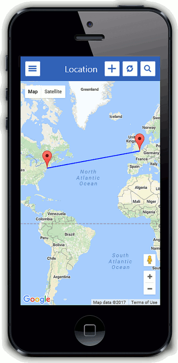
using DevExpress.ExpressApp; using DevExpress.ExpressApp.Maps.Mobile; using DevExpress.ExpressApp.Maps.Mobile.Editors; using DevExpress.ExpressApp.Maps.Mobile.Helpers; using Newtonsoft.Json; using System.Collections.Generic; //... public class MobilePolylineController : ViewController<ListView> { public MobilePolylineController() { TargetViewId = "MapsMarker_ListView"; } protected override void OnViewControlsCreated() { base.OnViewControlsCreated(); MobileMapsListEditor mobileMapsListEditor = View.Editor as MobileMapsListEditor; if (mobileMapsListEditor != null) { Map map = mobileMapsListEditor.Control as Map; map.OnCustomize = GetCustomizeScript(); } } private IEnumerable<MapPoint> GetPolylinePoints() { List<MapPoint> polylinePoints = new List<MapPoint>(); polylinePoints.Add(new MapPoint(40.7, -74)); polylinePoints.Add(new MapPoint(50.3, 0.7)); return polylinePoints; } private string GetCustomizeScript() { var polylines = JsonConvert.SerializeObject(GetPolylinePoints()); return string.Format( @"(function(mapInstance) {{ mapInstance.on('ready', function(e) {{ var googleMap = e.originalMap; var flightPlanCoordinates = {0}; var flightPath = new google.maps.Polyline({{ path: flightPlanCoordinates, strokeColor: '#0000FF', strokeOpacity: 1.0, strokeWeight: 2 }}); window.flightPath = flightPath; flightPath.setMap(googleMap); }}); }})", polylines); } }Run the application. The result is demonstrated in the image below.
See Also