GeoMapCoordinateSystem.CircularScrollingMode Property
Gets or sets a value that indicates which map items can be circularly scrolled.
Namespace: DevExpress.XtraMap
Assembly: DevExpress.XtraMap.v19.2.dll
Declaration
[DefaultValue(CircularScrollingMode.None)]
public CircularScrollingMode CircularScrollingMode { get; set; }Property Value
| Type | Default | Description |
|---|---|---|
| CircularScrollingMode | **None** | The value that indicates which map items are available for circular scrolling. |
Available values:
| Name | Description |
|---|---|
| None | No map elements are circularly scrolled. |
| TilesAndVectorItems | Tiles and vector items are circularly scrolled. |
Remarks
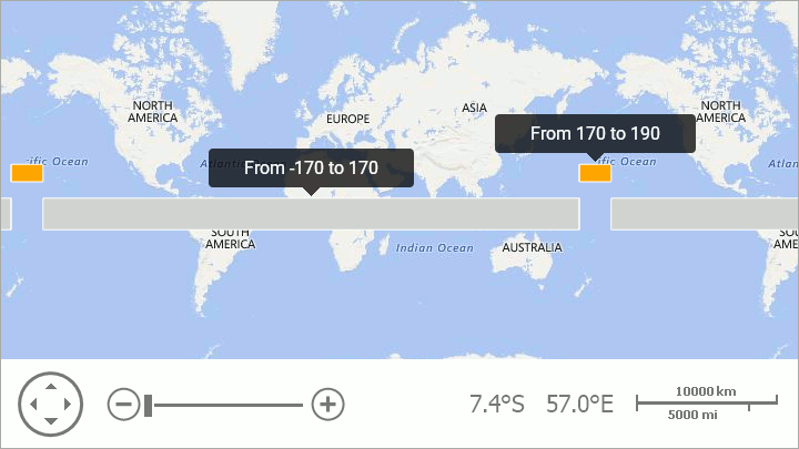
Note that, a map shape should fulfill the following condition to cross the 180th meridian: one or several points’ longitudes should exceed the 180 (-180) limit:
MapPolygon polygon = new MapPolygon();
polygon.Points.Add(new GeoPoint(10, -170));
polygon.Points.Add(new GeoPoint(10, 170));
polygon.Points.Add(new GeoPoint(-10, 170));
polygon.Points.Add(new GeoPoint(-10, -170));
vectorItemStorage.Items.Add(polygon);

// Point longitudes enclose the 180 meridian.
MapPolygon polygonCross180 = New MapPolygon();
polygonCross180.Fill = Color.Orange;
polygonCross180.Points.Add(new GeoPoint(30, 190));
polygonCross180.Points.Add(new GeoPoint(30, 170));
polygonCross180.Points.Add(new GeoPoint(20, 170));
polygonCross180.Points.Add(new GeoPoint(20, 190));
vectorItemStorage.Items.Add(polygon180);
The code above produces the following image:
See Also