MapPolyline Class
The class used to draw a polyline on a map.
Namespace: DevExpress.Xpf.Map
Assembly: DevExpress.Xpf.Map.v20.2.dll
NuGet Packages: DevExpress.WindowsDesktop.Wpf.Map, DevExpress.Wpf.Map
Declaration
Related API Members
The following members return MapPolyline objects:
Remarks
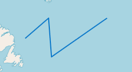
The following image shows an example of a map polyline shape.
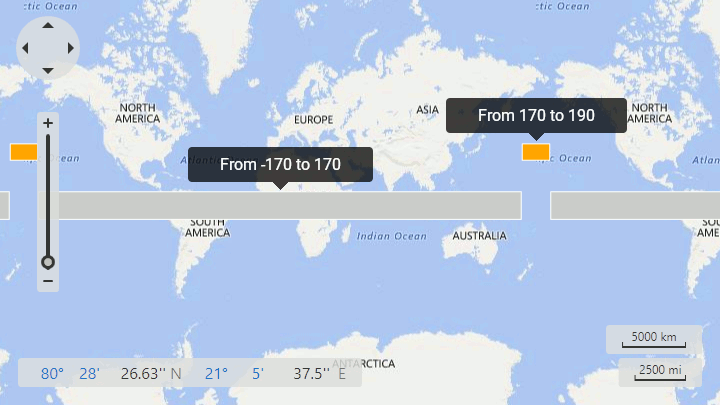
Note that, a map shape should fulfill the following condition to cross the 180th meridian: one or several points’ longitudes should exceed the 180 (-180) limit:
<dxm:MapItemStorage>
    <dxm:MapItemStorage.Items>
        <dxm:MapPolygon>
            <dxm:MapPolygon.Points>
                <dxm:GeoPoint Latitude="-10" Longitude="-170"/>
                <dxm:GeoPoint Latitude="-10" Longitude="170"/>
                <dxm:GeoPoint Latitude="10" Longitude="170"/>
                <dxm:GeoPoint Latitude="10" Longitude="-170"/>
            </dxm:MapPolygon.Points>
        </dxm:MapPolygon>
        <dxm:MapPolygon Fill="Orange">
            <dxm:MapPolygon.Points>
                <dxm:GeoPoint Latitude="30" Longitude="170"/>
                <dxm:GeoPoint Latitude="30" Longitude="190"/>
                <dxm:GeoPoint Latitude="40" Longitude="190"/>
                <dxm:GeoPoint Latitude="40" Longitude="170"/>
            </dxm:MapPolygon.Points>
        </dxm:MapPolygon>
    </dxm:MapItemStorage.Items>
</dxm:MapItemStorage>
The code above produces the following image:
Example
<dxm:MapPolyline>
    <dxm:MapPolyline.Points>
        <dxm:GeoPoint>0, 0</dxm:GeoPoint>
        <dxm:GeoPoint>-20, -10</dxm:GeoPoint>
        <dxm:GeoPoint>-10, -20</dxm:GeoPoint>
    </dxm:MapPolyline.Points>
</dxm:MapPolyline>
Inheritance
See Also