MapPolygon Class
The class used to draw a polygon on a map.
Namespace: DevExpress.Xpf.Map
Assembly: DevExpress.Xpf.Map.v19.2.dll
Declaration
public class MapPolygon :
    MapShape,
    ISupportCoordPoints,
    IPolygonCore,
    IPointContainerCore,
    IEditableItem,
ISimplifiableItemRelated API Members
The following members return MapPolygon objects:
Remarks
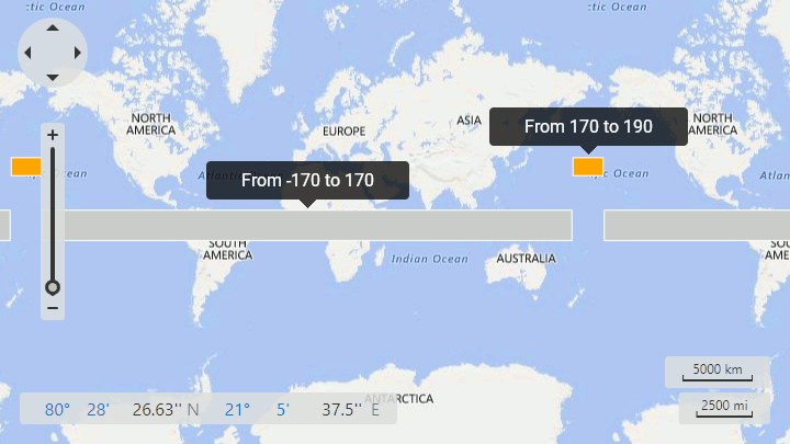
The following image shows an example of a map polygon shape.

Note that, a map shape should fulfill the following condition to cross the 180th meridian: one or several points’ longitudes should exceed the 180 (-180) limit:
<dxm:MapItemStorage>
    <dxm:MapItemStorage.Items>
        <dxm:MapPolygon>
            <dxm:MapPolygon.Points>
                <dxm:GeoPoint Latitude="-10" Longitude="-170"/>
                <dxm:GeoPoint Latitude="-10" Longitude="170"/>
                <dxm:GeoPoint Latitude="10" Longitude="170"/>
                <dxm:GeoPoint Latitude="10" Longitude="-170"/>
            </dxm:MapPolygon.Points>
        </dxm:MapPolygon>
        <dxm:MapPolygon Fill="Orange">
            <dxm:MapPolygon.Points>
                <dxm:GeoPoint Latitude="30" Longitude="170"/>
                <dxm:GeoPoint Latitude="30" Longitude="190"/>
                <dxm:GeoPoint Latitude="40" Longitude="190"/>
                <dxm:GeoPoint Latitude="40" Longitude="170"/>
            </dxm:MapPolygon.Points>
        </dxm:MapPolygon>
    </dxm:MapItemStorage.Items>
</dxm:MapItemStorage>
The code above produces the following image:
Example
Note
A complete sample project is available at https://github.com/DevExpress-Examples/how-to-add-different-types-of-vector-items-to-a-vector-layer-t145602.
<dxm:MapPolygon>
    <dxm:MapPolygon.Points>
        <dxm:GeoPoint>10, 10</dxm:GeoPoint>
        <dxm:GeoPoint>20, 10</dxm:GeoPoint>
        <dxm:GeoPoint>10, 20</dxm:GeoPoint>
    </dxm:MapPolygon.Points>
</dxm:MapPolygon>
Related GitHub Examples
The following code snippets (auto-collected from DevExpress Examples) contain references to the MapPolygon class.
Note
The algorithm used to collect these code examples remains a work in progress. Accordingly, the links and snippets below may produce inaccurate results. If you encounter an issue with code examples below, please use the feedback form on this page to report the issue.